Hail Size Events
Overview
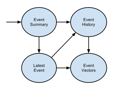
This portion of the API concerns hail size events, which are polygon data affecting a geographic region (defined by an extent) or location (defined by a point). There are 4 request types, providing various levels of detail. Each response identifies a possible transition to further information. These can be depicted as follows:
Definition of “Event”: An event is defined as a 24 hour period of time.
For requests that return a “date” between 1/1/2009 and 12/31/13 in the response, the 24 hour period for that particular event starts at 12Z on the date returned in the response. For example, the date “2012-05-03” refers to the 24 hour time period from 2012-05-03T12:00:00Z to 2013-05-04T12:00:00Z.
For requests that return a “date” on or after 1/1/14 in the response, the 24 hour period for that particular event starts at 6Z on the date returned in the response. For example, the date “2012-05-03” refers to the 24 hour time period from 2012-05-03T06:00:00Z to 2013-05-04T06:00:00Z.
By default, the requests return hailsize events within US. But, by setting the keyword “region=CA” in the request parameters, canadian hailsize events can be returned.
Event Summary
This request is the “entry point” for the hail size event portion of the API. It returns the total number dates where a hail size of greater than or equal to 0.75” in diameter was analyzed at a given location, proximity for a given location with a radius(default unit is mile), or region within a date range (the last 90 days by default) as JSON or XML. Links to the latest event and event history (within the same date range) are included in the response to facilitate client-side transitions.
URI Examples
forensic.api.wdtinc.com/v2/hailsize/summary/+DD.ddd-DDD.ddd?begin=&end=&u=&t=
forensic.api.wdtinc.com/v2/hailsize/summary/+DD.ddd-DDD.ddd.xml?begin=&end=&u=&t=

forensic.api.wdtinc.com/v2/hailsize/summary/+DD.ddd-DDD.ddd?radius=&begin=&end=&u=&t=
forensic.api.wdtinc.com/v2/hailsize/summary/+DD.ddd-DDD.ddd.xml?radius=&begin=&end=&u=&t=

forensic.api.wdtinc.com/v2/hailsize/summary/+DD.ddd-DDD.ddd+DD.ddd-DDD.ddd?begin=&end=&u=&t=
forensic.api.wdtinc.com/v2/hailsize/summary/+DD.ddd-DDD.ddd+DD.ddd-DDD.ddd.xml?begin=&end=&u=&t=
See Request Format for a description of the parameters.
JSON Response
The JSON representation of a location-based resource is structured as follows (loosely based on Google’s JSON style guide):
{
    "apiVersion": "2.5.8",
    "eventSummary": {
        "selfLink": "/v2/hailsize/summary/+DD.ddd-DDD.ddd?begin=&end=&u=&t=",
        "dateRange": {
            "begin": "YYYY-MM-DDThh:mm:ssZ",
            "end": "YYYY-MM-DDThh:mm:ssZ"
        },
        "location": "+DD.ddd-DDD.ddd",
        "eventCount": nn,
        "eventHistoryLink": "/v2/hailsize/history/+DD.ddd-DDD.ddd?begin=&end=&u=&t=",
        "latestEventLink": "/v2/hailsize/latest/+DD.ddd-DDD.ddd?begin=&end=&u=&t="
    }
}
The JSON representation of a proximity-based resource is structured as follows (loosely based on Google’s JSON style guide):
{
    "apiVersion": "2.5.8",
    "eventSummary": {
        "selfLink": "/v2/hailsize/summary/+DD.ddd-DDD.ddd?radius=&begin=&end=&u=&t=",
        "dateRange": {
            "begin": "YYYY-MM-DDThh:mm:ssZ",
            "end": "YYYY-MM-DDThh:mm:ssZ"
        },
        "location": "+DD.ddd-DDD.ddd",
        "eventCount": nn,
        "radius": {
            "unit": "mile|km",
            "value": "DD.dd"
        },
        "eventHistoryLink": "/v2/hailsize/history/+DD.ddd-DDD.ddd?radius=&begin=&end=&u=&t=",
        "latestEventLink": "/v2/hailsize/latest/+DD.ddd-DDD.ddd?radius=&begin=&end=&u=&t="
    }
}
The JSON representation of a region-based resource is structured as follows (loosely based on Google’s JSON style guide):
{
    "apiVersion": "2.5.8",
    "eventSummary": {
        "selfLink": "/v2/hailsize/summary/+DD.ddd-DDD.ddd+DD.ddd-DDD.ddd?begin=&end=&u=&t=",
        "dateRange": {
            "begin": "YYYY-MM-DDThh:mm:ssZ",
            "end": "YYYY-MM-DDThh:mm:ssZ"
        },
        "region": "+DD.ddd-DDD.ddd+DD.ddd-DDD.ddd",
        "eventCount": nn,
        "eventHistoryLink": "/v2/hailsize/history/+DD.ddd-DDD.ddd+DD.ddd-DDD.ddd?begin=&end=&u=&t=",
        "latestEventLink": "/v2/hailsize/latest/+DD.ddd-DDD.ddd+DD.ddd-DDD.ddd?begin=&end=&u=&t="
    }
}
XML Response
The XML representation of a location-based resource is structured as follows (based on Google’s XML style guide):
<?xml version="1.0" encoding="UTF-8"?>
<eventSummary xmlns="http://forensic.api.wdtinc.com/hailsize"
xmlns:xlink="http://www.w3.org/1999/xlink"
xlink:href="/v2/hailsize/summary/+DD.ddd-DDD.ddd.xml?begin=&end=&u=&t=">
<dateRange begin="YYYY-MM-DDThh:mm:ssZ" end="YYYY-MM-DDThh:mm:ssZ" />
<location format="iso6709">+DD.ddd-DDD.ddd</location>
<eventCount>nn</eventCount>
<eventHistory xlink:href="/v2/hailsize/history/+DD.ddd-DDD.ddd.xml?begin=&end=&u=&t=" />
<latestEvent xlink:href="/v2/hailsize/latest/+DD.ddd-DDD.ddd.xml?begin=&end=&u=&t=" />
</eventSummary>
The XML representation of a proximity-based resource is structured as follows (based on Google’s XML style guide):
<?xml version="1.0" encoding="UTF-8"?>
<eventSummary xmlns="http://forensic.api.wdtinc.com/hailsize"
xmlns:xlink="http://www.w3.org/1999/xlink"
xlink:href="/v2/hailsize/summary/+DD.ddd-DDD.ddd.xml?radius=begin=&end=&u=&t=">
<dateRange begin="YYYY-MM-DDThh:mm:ssZ" end="YYYY-MM-DDThh:mm:ssZ" />
<location format="iso6709">+DD.ddd-DDD.ddd</location>
<eventCount>nn</eventCount>
<radius unit="mile|km">DD.dd</radius>
<eventHistory xlink:href="/v2/hailsize/history/+DD.ddd-DDD.ddd.xml?radius=&begin=&end=&u=&t=" />
<latestEvent xlink:href="/v2/hailsize/latest/+DD.ddd-DDD.ddd.xml?radius=&begin=&end=&u=&t=" />
</eventSummary>
The XML representation of a region-based resource is structured as follows (based on Google’s XML style guide):
<?xml version="1.0" encoding="UTF-8"?>
<eventSummary xmlns="http://forensic.api.wdtinc.com/hailsize"
xmlns:xlink="http://www.w3.org/1999/xlink"
xlink:href="/v2/hailsize/summary/+DD.ddd-DDD.ddd+DD.ddd-DDD.ddd.xml?begin=&end=&u=&t=">
<dateRange begin="YYYY-MM-DDThh:mm:ssZ" end="YYYY-MM-DDThh:mm:ssZ" />
<region format="iso6709">+DD.ddd-DDD.ddd+DD.ddd-DDD.ddd</region>
<eventCount>nn</eventCount>
<eventHistory xlink:href="/v2/hailsize/history/+DD.ddd-DDD.ddd+DD.ddd-DDD.ddd.xml?begin=&end=&u=&t=" />
<latestEvent xlink:href="/v2/hailsize/latest/+DD.ddd-DDD.ddd+DD.ddd-DDD.ddd.xml?begin=&end=&u=&t=" />
</eventSummary>
Latest Event
This request returns the most recent hail size event impacting a given location, or a proximity with a given location and a radius (default unit is mile), or region within a date range (all available history by default) as JSON or XML. Event details include the ID, date, and maximum estimated hail size in inches. Links to the event history (within the same date range) and event vectors (for the latest event) are included in the response to facilitate client-side transitions.
URI Examples
forensic.api.wdtinc.com/v2/hailsize/latest/+DD.ddd-DDD.ddd?begin=&end=&u=&t=
forensic.api.wdtinc.com/v2/hailsize/latest/+DD.ddd-DDD.ddd.xml?begin=&end=&u=&t=

forensic.api.wdtinc.com/v2/hailsize/latest/+DD.ddd-DDD.ddd?radius=&begin=&end=&u=&t=
forensic.api.wdtinc.com/v2/hailsize/latest/+DD.ddd-DDD.ddd.xml?radius=&begin=&end=&u=&t=

forensic.api.wdtinc.com/v2/hailsize/latest/+DD.ddd-DDD.ddd+DD.ddd-DDD.ddd?begin=&end=&u=&t=
forensic.api.wdtinc.com/v2/hailsize/latest/+DD.ddd-DDD.ddd+DD.ddd-DDD.ddd.xml?begin=&end=&u=&t=
See Request Format for a description of the parameters.
JSON Response
The JSON representation of a location-based resource is structured as follows (loosely based on Google’s JSON style guide):
{
    "apiVersion": "2.5.8",
    "latestEvent": {
        "selfLink": "/v2/hailsize/latest/+DD.ddd-DDD.ddd?begin=&end=&u=&t=",
        "dateRange": {
            "begin": "YYYY-MM-DDThh:mm:ssZ",
            "end": "YYYY-MM-DDThh:mm:ssZ"
        },
        "location": "+DD.ddd-DDD.ddd",
        "event": {
            "id": "",
            "date": "YYYY-MM-DD",
            "size": {
                "unit": "inches",
                "value": "DD.dd"
            },
            "vectorsLink": "/v2/hailsize/vectors/+DD.ddd-DDD.ddd/dddddddddd?u=&t="
        },
        "eventHistoryLink": "/v2/hailsize/history/+DD.ddd-DDD.ddd?begin=&end=&u=&t="
    }
}
The JSON representation of a proximity-based resource is structured as follows (loosely based on Google’s JSON style guide):
{
    "apiVersion": "2.5.8",
    "latestEvent": {
        "selfLink": "/v2/hailsize/latest/+DD.ddd-DDD.ddd?radius=&begin=&end=&u=&t=",
        "dateRange": {
            "begin": "YYYY-MM-DDThh:mm:ssZ",
            "end": "YYYY-MM-DDThh:mm:ssZ"
        },
        "location": "+DD.ddd-DDD.ddd",
        "radius": {
            "unit": "mile|km",
            "value": "DD.dd"
        },
        "event": {
            "id": "",
            "date": "YYYY-MM-DD",
            "size": {
                "unit": "inches",
                "value": "DD.dd"
            },
            "vectorsLink": "/v2/hailsize/vectors/+DD.ddd-DDD.ddd/dddddddddd?radius=&u=&t="
        },
        "eventHistoryLink": "/v2/hailsize/history/+DD.ddd-DDD.ddd?radius=&begin=&end=&u=&t="
    }
}
The JSON representation of a region-based resource is structured as follows (loosely based on Google’s JSON style guide):
{
    "apiVersion": "2.5.8",
    "latestEvent": {
        "selfLink": "/v2/hailsize/latest/+DD.ddd-DDD.ddd+DD.ddd-DDD.ddd?begin=&end=&u=&t=",
        "dateRange": {
            "begin": "YYYY-MM-DDThh:mm:ssZ",
            "end": "YYYY-MM-DDThh:mm:ssZ"
        },
        "region": "+DD.ddd-DDD.ddd+DD.ddd-DDD.ddd",
        "event": {
            "id": "",
            "date": "YYYY-MM-DD",
            "size": {
                "unit": "inches",
                "value": "DD.dd"
            },
            "vectorsLink": "/v2/hailsize/vectors/+DD.ddd-DDD.ddd+DD.ddd-DDD.ddd/dddddddddd?u=&t="
        },
        "eventHistoryLink": "/v2/hailsize/history/+DD.ddd-DDD.ddd+DD.ddd-DDD.ddd?begin=&end=&u=&t="
    }
}
XML Response
The XML representation of a location-based resource is structured as follows (based on Google’s XML style guide):
<?xml version="1.0" encoding="UTF-8"?>
<latestEvent xmlns="http://forensic.api.wdtinc.com/hailsize"
xmlns:xlink="http://www.w3.org/1999/xlink"
xlink:href="/v2/hailsize/latest/+DD.ddd-DDD.ddd.xml?begin=&end=&u=&t=">
<dateRange begin="YYYY-MM-DDThh:mm:ssZ" end="YYYY-MM-DDThh:mm:ssZ" />
<location format="iso6709">+DD.ddd-DDD.ddd</location>
<event id="">
<date>YYYY-MM-DD</date>
<size unit="inches">DD.dd</size>
<vectors xlink:href="/v2/hailsize/vectors/+DD.ddd-DDD.ddd/dddddddddd?u=&t=" />
</event>
<eventHistory xlink:href="/v2/hailsize/history/+DD.ddd-DDD.ddd.xml?begin=&end=&u=&t=" />
</latestEvent>
The XML representation of a proximity-based resource is structured as follows (based on Google’s XML style guide):
<?xml version="1.0" encoding="UTF-8"?>
<latestEvent xmlns="http://forensic.api.wdtinc.com/hailsize"
xmlns:xlink="http://www.w3.org/1999/xlink"
xlink:href="/v2/hailsize/latest/+DD.ddd-DDD.ddd.xml?radius=&begin=&end=&u=&t=">
<dateRange begin="YYYY-MM-DDThh:mm:ssZ" end="YYYY-MM-DDThh:mm:ssZ" />
<location format="iso6709">+DD.ddd-DDD.ddd</location>
<radius unit="mile|km">DD.dd</radius>
<event id="">
<date>YYYY-MM-DD</date>
<size unit="inches">DD.dd</size>
<vectors xlink:href="/v2/hailsize/vectors/+DD.ddd-DDD.ddd/dddddddddd?radius=&u=&t=" />
</event>
<eventHistory xlink:href="/v2/hailsize/history/+DD.ddd-DDD.ddd.xml?radius=&begin=&end=&u=&t=" />
</latestEvent>
The XML representation of a region-based resource is structured as follows (based on Google’s XML style guide):
<?xml version="1.0" encoding="UTF-8"?>
<latestEvent xmlns="http://forensic.api.wdtinc.com/hailsize"
xmlns:xlink="http://www.w3.org/1999/xlink"
xlink:href="/v2/hailsize/latest/+DD.ddd-DDD.ddd+DD.ddd-DDD.ddd.xml?begin=&end=&u=&t=">
<dateRange begin="YYYY-MM-DDThh:mm:ssZ" end="YYYY-MM-DDThh:mm:ssZ" />
<region format="iso6709">+DD.ddd-DDD.ddd+DD.ddd-DDD.ddd</region>
<event id="">
<date>YYYY-MM-DD</date>
<size unit="inches">DD.dd</size>
<vectors xlink:href="/v2/hailsize/vectors/+DD.ddd-DDD.ddd+DD.ddd-DDD.ddd/dddddddddd?u=&t=" />
</event>
<eventHistory xlink:href="/v2/hailsize/history/+DD.ddd-DDD.ddd+DD.ddd-DDD.ddd.xml?begin=&end=&u=&t=" />
</latestEvent>
Event History
This request returns the history of hail size events impacting a given location, or a proximity with a given location and radius (default unit is mile), or region within a date range (the last 90 days by default) as JSON or XML. A link to the event vectors (for each event in the history) is included in the response to facilitate a client-side transition.
URI Examples
forensic.api.wdtinc.com/v2/hailsize/history/+DD.ddd-DDD.ddd?begin=&end=&u=&t=
forensic.api.wdtinc.com/v2/hailsize/history/+DD.ddd-DDD.ddd.xml?begin=&end=&u=&t=

forensic.api.wdtinc.com/v2/hailsize/history/+DD.ddd-DDD.ddd?radius=&begin=&end=&u=&t=
forensic.api.wdtinc.com/v2/hailsize/history/+DD.ddd-DDD.ddd.xml?radius=&begin=&end=&u=&t=

forensic.api.wdtinc.com/v2/hailsize/history/+DD.ddd-DDD.ddd+DD.ddd-DDD.ddd?begin=&end=&u=&t=
forensic.api.wdtinc.com/v2/hailsize/history/+DD.ddd-DDD.ddd+DD.ddd-DDD.ddd.xml?begin=&end=&u=&t=
See Request Format for a description of the parameters.
JSON Response
The JSON representation of a location-based resource is structured as follows (loosely based on Google’s JSON style guide):
{
    "apiVersion": "2.5.8",
    "eventHistory": {
        "selfLink": "/v2/hailsize/history/+DD.ddd-DDD.ddd?begin=&end=&u=&t=",
        "dateRange": {
            "begin": "YYYY-MM-DDThh:mm:ssZ",
            "end": "YYYY-MM-DDThh:mm:ssZ"
        },
        "location": "+DD.ddd-DDD.ddd",
        "events": [
            {
                "id": "",
                "date": "YYYY-MM-DD",
                "size": {
                    "unit": "inches",
                    "value": "DD.dd"
                },
                "vectorsLink": "/v2/hailsize/vectors/+DD.ddd-DDD.ddd/dddddddddd?u=&t="
            },
            {
                "id": "",
                "date": "YYYY-MM-DD",
                "size": {
                    "unit": "inches",
                    "value": "DD.dd"
                },
                "vectorsLink": "/v2/hailsize/vectors/+DD.ddd-DDD.ddd/dddddddddd?u=&t="
            },
            :
            :
        ]
    }
}
The JSON representation of a proximity-based resource is structured as follows (loosely based on Google’s JSON style guide):
{
    "apiVersion": "2.5.8",
    "eventHistory": {
        "selfLink": "/v2/hailsize/history/+DD.ddd-DDD.ddd?radius=&begin=&end=&u=&t=",
        "dateRange": {
            "begin": "YYYY-MM-DDThh:mm:ssZ",
            "end": "YYYY-MM-DDThh:mm:ssZ"
        },
        "location": "+DD.ddd-DDD.ddd",
        "radius": {
            "unit": "mile|km",
            "value": "DD.dd"
        },
        "events": [
            {
                "id": "",
                "date": "YYYY-MM-DD",
                "size": {
                    "unit": "inches",
                    "value": "DD.dd"
                },
                "vectorsLink": "/v2/hailsize/vectors/+DD.ddd-DDD.ddd/dddddddddd?radius=&u=&t="
            },
            :
            :
        ]
    }
}
The JSON representation of a region-based resource is structured as follows (loosely based on Google’s JSON style guide):
{
    "apiVersion": "2.5.8",
    "eventHistory": {
        "selfLink": "/v2/hailsize/history/+DD.ddd-DDD.ddd+DD.ddd-DDD.ddd?begin=&end=&u=&t=",
        "dateRange": {
            "begin": "YYYY-MM-DDThh:mm:ssZ",
            "end": "YYYY-MM-DDThh:mm:ssZ"
        },
        "region": "+DD.ddd-DDD.ddd+DD.ddd-DDD.ddd",
        "events": [
            {
                "id": "",
                "date": "YYYY-MM-DD",
                "size": {
                    "unit": "inches",
                    "value": "DD.dd"
                },
                "vectorsLink": "/v2/hailsize/vectors/+DD.ddd-DDD.ddd+DD.ddd-DDD.ddd/dddddddddd?u=&t="
            },
            :
            :
        ]
    }
}
XML Response
The XML representation of a location-based resource is structured as follows (based on Google’s XML style guide):
<?xml version="1.0" encoding="UTF-8"?>
<eventHistory xmlns="http://forensic.api.wdtinc.com/hailsize"
xmlns:xlink="http://www.w3.org/1999/xlink"
xlink:href="/v2/hailsize/history/+DD.ddd-DDD.ddd.xml?begin=&end=&u=&t=">
<dateRange begin="YYYY-MM-DDThh:mm:ssZ" end="YYYY-MM-DDThh:mm:ssZ" />
<location format="iso6709">+DD.ddd-DDD.ddd</location>
<event id="">
<date>YYYY-MM-DD</date>
<size unit="inches">DD.dd</size>
<vectors xlink:href="/v2/hailsize/vectors/+DD.ddd-DDD.ddd/dddddddddd?u=&t=" />
</event>
<event id="">
<date>YYYY-MM-DD</date>
<size unit="inches">DD.dd</size>
<vectors xlink:href="/v2/hailsize/vectors/+DD.ddd-DDD.ddd/dddddddddd?u=&t=" />
</event>
:
:
</eventHistory>
The XML representation of a proximity-based resource is structured as follows (based on Google’s XML style guide):
<?xml version="1.0" encoding="UTF-8"?>
<eventHistory xmlns="http://forensic.api.wdtinc.com/hailsize"
xmlns:xlink="http://www.w3.org/1999/xlink"
xlink:href="/v2/hailsize/history/+DD.ddd-DDD.ddd.xml?radius=&begin=&end=&u=&t=">
<dateRange begin="YYYY-MM-DDThh:mm:ssZ" end="YYYY-MM-DDThh:mm:ssZ" />
<location format="iso6709">+DD.ddd-DDD.ddd</location>
<radius unit="mile|km">DD.dd</radius>
<event id="">
<date>YYYY-MM-DD</date>
<size unit="inches">DD.dd</size>
<vectors xlink:href="/v2/hailsize/vectors/+DD.ddd-DDD.ddd/dddddddddd?radius=&u=&t=" />
</event>
<event id="">
<date>YYYY-MM-DD</date>
<size unit="inches">DD.dd</size>
<vectors xlink:href="/v2/hailsize/vectors/+DD.ddd-DDD.ddd/dddddddddd?radius=&u=&t=" />
</event>
:
:
</eventHistory>
The XML representation of a region-based resource is structured as follows (based on Google’s XML style guide):
<?xml version="1.0" encoding="UTF-8"?>
<eventHistory xmlns="http://forensic.api.wdtinc.com/hailsize"
xmlns:xlink="http://www.w3.org/1999/xlink"
xlink:href="/v2/hailsize/history/+DD.ddd-DDD.ddd.xml?begin=&end=&u=&t=">
<dateRange begin="YYYY-MM-DDThh:mm:ssZ" end="YYYY-MM-DDThh:mm:ssZ" />
<region format="iso6709">+DD.ddd-DDD.ddd+DD.ddd-DDD.ddd</region>
<event id="">
<date>YYYY-MM-DD</date>
<size unit="inches">DD.dd</size>
<vectors xlink:href="/v2/hailsize/vectors/+DD.ddd-DDD.ddd+DD.ddd-DDD.ddd/dddddddddd?u=&t=" />
</event>
<event id="">
<date>YYYY-MM-DD</date>
<size unit="inches">DD.dd</size>
<vectors xlink:href="/v2/hailsize/vectors/+DD.ddd-DDD.ddd+DD.ddd-DDD.ddd/dddddddddd?u=&t=" />
</event>
:
:
</eventHistory>
Event Vectors
This request returns the vector geometry depicting hail size events that impacted a given location, or a proximity with a given location and radius (default unit is mile), or region on a given date. Results are returned as GeoJSON or KML. No transitions are available from the response. An empty feature collection is returned if there are no events.
URI Examples
forensic.api.wdtinc.com/v2/hailsize/vectors/+DD.ddd-DDD.ddd/ssssssssss?radius=&u=&t=
forensic.api.wdtinc.com/v2/hailsize/vectors/+DD.ddd-DDD.ddd/ssssssssss.kml?radius=&u=&t=

forensic.api.wdtinc.com/v2/hailsize/vectors/+DD.ddd-DDD.ddd/YYYY-MM-DD?radius=&u=&t=
forensic.api.wdtinc.com/v2/hailsize/vectors/+DD.ddd-DDD.ddd/YYYY-MM-DD.kml?radius=&u=&t=

forensic.api.wdtinc.com/v2/hailsize/vectors/+DD.ddd-DDD.ddd/YYYY-MM-DDThh:mm:ssZ?radius=&u=&t=
forensic.api.wdtinc.com/v2/hailsize/vectors/+DD.ddd-DDD.ddd/YYYY-MM-DDThh:mm:ssZ.kml?radius=&u=&t=

forensic.api.wdtinc.com/v2/hailsize/vectors/+DD.ddd-DDD.ddd+DD.ddd-DDD.ddd/ssssssssss?u=&t=
forensic.api.wdtinc.com/v2/hailsize/vectors/+DD.ddd-DDD.ddd+DD.ddd-DDD.ddd/ssssssssss.kml?u=&t=

forensic.api.wdtinc.com/v2/hailsize/vectors/+DD.ddd-DDD.ddd+DD.ddd-DDD.ddd/YYYY-MM-DDThh:mm:ssZ?u=&t=
forensic.api.wdtinc.com/v2/hailsize/vectors/+DD.ddd-DDD.ddd+DD.ddd-DDD.ddd/YYYY-MM-DDThh:mm:ssZ.kml?u=&t=
See Request Format for a description of the parameters.
GeoJSON Response
The GeoJSON representation of a proximity-based resource is structured as follows:
{
    "apiVersion": "2.5.8",
    "eventVectors": {
        "selfLink": "/v2/hailsize/vectors/+DD.ddd-DDD.ddd/dddddddddd?radius=&u=&t=",
        "date": "YYYY-MM-DD",
        "location": "+DD.ddd-DDD.ddd",
        "radius": {
            "unit": "mile|km",
            "value": "DD.dd"
        },
        "type": "FeatureCollection",
        "features": [
            {
                "type": "Feature",
                "geometry": {
                    "type": "Polygon",
                    "coordinates": [
                        [ [-102.3555, 39.8420], [-99.8945, 39.8420], ... ]
                    ]
                },
                "properties": {
                    "id": "",
                    "size": {
                        "unit": "inches",
                        "value": "DD.dd"
                    }
                }
            },
            {
                "type": "Feature",
                "geometry": {
                    "type": "Polygon",
                    "coordinates": [
                        [ [-96.9941, 36.3148], [-93.2148, 36.3148], ... ]
                    ]
                },
                "properties": {
                    "id": "",
                    "size": {
                        "unit": "inches",
                        "value": "DD.dd"
                    }
                }
            },
            :
            :
        ]
    }
}
The GeoJSON representation of a region-based resource is structured as follows:
{
    "apiVersion": "2.5.8",
    "eventVectors": {
        "selfLink": "/v2/hailsize/vectors/+DD.ddd-DDD.ddd+DD.ddd-DDD.ddd/dddddddddd?u=&t=",
        "date": "YYYY-MM-DD",
        "region": "+DD.ddd-DDD.ddd+DD.ddd-DDD.ddd",
        "type": "FeatureCollection",
        "features": [
            {
                "type": "Feature",
                "geometry": {
                    "type": "Polygon",
                    "coordinates": [
                        [ [-102.3555, 39.8420], [-99.8945, 39.8420], ... ]
                    ]
                },
                "properties": {
                    "id": "",
                    "size": {
                        "unit": "inches",
                        "value": "DD.dd"
                    }
                }
            },
            {
                "type": "Feature",
                "geometry": {
                    "type": "Polygon",
                    "coordinates": [
                        [ [-96.9941, 36.3148], [-93.2148, 36.3148], ... ]
                    ]
                },
                "properties": {
                    "id": "",
                    "size": {
                        "unit": "inches",
                        "value": "DD.dd"
                    }
                }
            },
            :
            :
        ]
    }
}
KML Response
The KML representation of a proximity-based resource is structured as follows:
<?xml version="1.0" encoding="UTF-8"?>
<kml xmlns="http://www.opengis.net/kml/2.2">
<Document>
<name>Hail Size Events</name>
<ExtendedData>
<Data name="selfLink">
<value>/v2/hailsize/vectors/+DD.ddd-DDD.ddd/dddddddddd?radius=&u=&t=</value>
</Data>
<Data name="date"><value>YYYY-MM-DD</value></Data>
<Data name="location"><value>+DD.ddd-DDD.ddd</value></Data>
<Data name="radius" unit="mile|km"><value>DD.dd</value></Data>
</ExtendedData>
<Placemark>
<name>8082258</name>
<ExtendedData>
<Data name="size"><value>DD.dd</value></Data>
<Data name="unit"><value>inches</value></Data>
</ExtendedData>
<Polygon>
<outerBoundaryIs>
<LinearRing>
<coordinates>-99.6442,33.3989 -99.6360,33.3777 ...</coordinates>
</LinearRing>
</outerBoundaryIs>
</Polygon>
</Placemark>
<Placemark>
<name>8082570</name>
<ExtendedData>
<Data name="size"><value>DD.dd</value></Data>
<Data name="unit"><value>inches</value></Data>
</ExtendedData>
<Polygon>
<outerBoundaryIs>
<LinearRing>
<coordinates>-99.6442,33.4089 -99.6370,33.3787 ...</coordinates>
</LinearRing>
</outerBoundaryIs>
</Polygon>
</Placemark>
:
:
</Document>
</kml>
The KML representation of a region-based resource is structured as follows:
<?xml version="1.0" encoding="UTF-8"?>
<kml xmlns="http://www.opengis.net/kml/2.2">
<Document>
<name>Hail Size Events</name>
<ExtendedData>
<Data name="selfLink">
<value>/v2/hailsize/vectors/+DD.ddd-DDD.ddd+DD.ddd-DDD.ddd/dddddddddd?u=&t=</value>
</Data>
<Data name="date"><value>YYYY-MM-DD</value></Data>
<Data name="region"><value>+DD.ddd-DDD.ddd+DD.ddd-DDD.ddd</value></Data>
</ExtendedData>
<Placemark>
<name>8082258</name>
<ExtendedData>
<Data name="size"><value>DD.dd</value></Data>
<Data name="unit"><value>inches</value></Data>
</ExtendedData>
<Polygon>
<outerBoundaryIs>
<LinearRing>
<coordinates>-99.6442,33.3989 -99.6360,33.3777 ...</coordinates>
</LinearRing>
</outerBoundaryIs>
</Polygon>
</Placemark>
<Placemark>
<name>8082570</name>
<ExtendedData>
<Data name="size"><value>DD.dd</value></Data>
<Data name="unit"><value>inches</value></Data>
</ExtendedData>
<Polygon>
<outerBoundaryIs>
<LinearRing>
<coordinates>-99.6442,33.4089 -99.6370,33.3787 ...</coordinates>
</LinearRing>
</outerBoundaryIs>
</Polygon>
</Placemark>
:
:
</Document>
</kml>